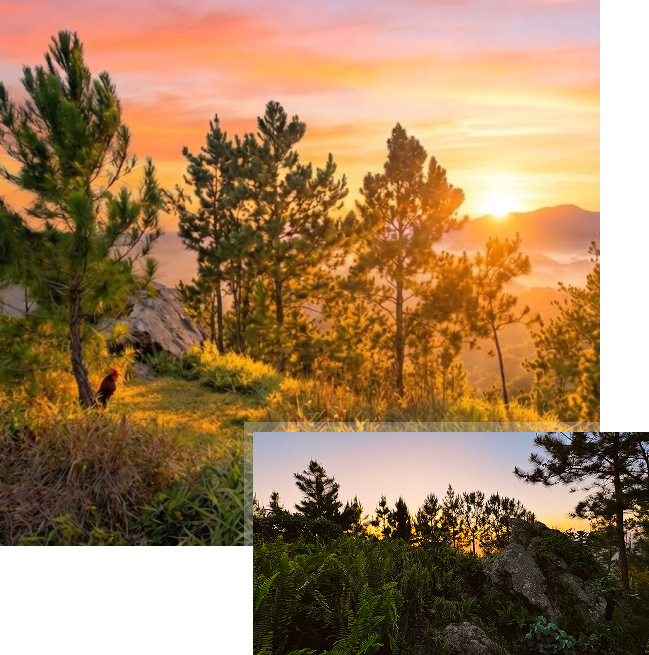
Monte El Gato rises within the mountainous heart of the Sierra de Cayey. Its pine-covered silhouette and rock-studded slopes create a well-defined profile that shapes a landscape of beauty and serenity.
This mountain and its immediate surroundings concentrate an uncommon combination of elements: Cretaceous volcanic rocks intersected by igneous intrusions and zones of hydrothermal alteration; evidence of historical mineral prospecting reflected in local place names; humid montane forests shaped by fog and orographic rainfall; pine plantations resulting from twentieth-century forestry experiments; and the biological memory of highly specialized species, such as the Golden Coquí, now considered extinct. All of this is integrated within a relatively compact area, where natural processes and human interventions have left overlapping traces.
Monte El Gato cannot be understood merely as an elevated point in the landscape. Its topographic position directly influences moisture capture, regional hydrological dynamics, and the formation of microclimates that have shaped both vegetation and historical land use. At the same time, its geology explains the presence of streams with mineralized sediments, the configuration of the current relief, and the interest the area has generated for exploration and management activities over time.
To provide a clear and accessible understanding of the site, the following section presents a synthesis of its main physical and environmental characteristics, serving as a general reference before examining in greater detail the elements that define Monte El Gato and its surroundings.
Monte El Gato.
Municipality of Cayey, Barrio Sumido, Puerto Rico.
Sierra de Cayey, southeastern sector of Puerto Rico's Cordillera Central
18° 05' 02″ N latitude and 66° 10' 48″ W longitude
Network of small mountain streams with short courses and flow regimes dependent on local precipitation and atmospheric moisture, contributing to larger watersheds associated with the La Plata and Patillas rivers.
Approximately 815 meters above sea level, corresponding to the summit mapped by the U.S. Geological Survey (USGS).
Humid tropical mountain climate, characterized by moderate temperatures compared with surrounding lowlands, high relative humidity, and frequent fog due to cloud immersion associated with the trade winds.
Predominantly humid montane forest, with the presence of Caribbean pine plantations (Pinus caribaea var. hondurensis) established during the twentieth century as part of forest management and watershed protection programs.
The rock formation known as Peñón del Gato; zones of hydrothermal alteration grouped under the local designation of the Monte El Gato Belt; and Quebrada La Mina, associated with evidence of historical mineral prospecting.
Area of high ecological interest due to its humid montane forest conditions and for having been one of the main historical habitats of the Golden Coquí (Eleutherodactylus jasperi), an endemic species currently considered extinct.
Area under planning for controlled visitation, with emphasis on defined trails, responsible management, visitor safety, and the possible establishment of a visitor area with controlled vehicle access.